

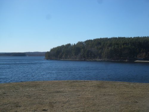
On the shoreline of the Quinapoxit river, opposite the Mass Central Railtrail in Boylston
We have spent the past several summers riding our tandem bike along the available railtrails within about 3 hour’s drive from our home in Bellingham, MA. We have two substantial portions of railtrail, the Blackstone River Bikeway and the Upper Charles Trail, both within about 15 minute’s drive from us, and a portion of a third proposed trail, the SNETT, within easy walking distance of our home.
Sometimes we are lucky enough to discover additional options for travel quite near to railtrails we’ve explored in the past. Our recent “explore” near the Wachusett Reservoir in north-central MA revealed a new spot where we’ll be able to travel on our bike when the weather is warmer.

Walkway, and stairs down to the river flowing out of the Wachusett Reservoir Dam in Clinton. Access gates to the walkway were locked when we visited in early March
Earlier in the day we’d walked a trail in Bolton and got some great views as we walked on former farmland, right across the street from Nashoba Valley Winery. From there we headed over to the impressive dam that created Wachusett Reservoir, located on Rt. 62 in Clinton, MA. We’d hoped to walk across the large dam, but gates providing access to the top of the dam were locked.

Access gates are presently locked to the walkway over the dam
It was difficult to find information about when, or if, these gates will be unlocked in warmer weather. We got views from the street, but walking across the dam would have offered a much nicer experience. Any information others know about access would be great to hear!
View next to the dam
From the dam, we headed south along Rt. 62, with the reservoir in view much of the ride. Turning right onto Rt. 140, we continued around the reservoir, heading north till we came to Beamon Street, where 140 takes a left (within sight of the stone church that juts out into the water), still hugging the shoreline of the reservoir. We followed 140 to the stop sign and turned left onto Thomas Street, but rather than parking at the Central Mass Railtrail parking, immediately in view of the top of the reservoir, we drove just past the parking, over the small bridge that crosses the Quinapoxit river, and hung a quick right onto a portion of road that hugs the river till it reaches a barrier restricting motorized access.

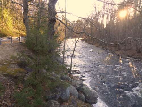
Building housing power turbines has restricted access, but the trail alongside the building is open to the public, down to the river
This is where we found several options for walking and biking on the opposite side of the river from where the Central Mass Railtrail travels. There are signs restricting access to the building that houses turbines for water power, at the end of the road. But there is a trail beside the restricted building that is open to the public, and carries you down to the river’s edge. A small footpath follows the shoreline of the river, and offers some nice views of the dam just upstream.
The road to this spot used to continue beyond the restricted building, and much of the paving on the road is intact. The day we visited was still too cold for biking, but we’re looking forward to venturing much farther than we were able to travel that day on foot. And so we will return, knowing we can ride on one side of the river, alongside folks visiting the railtrail, or we can choose to venture to the opposite side of the river as well.

View of the dam, just above the inlet for the turbines. The railtrail is on the opposite shore
We found the river views to be better on this “less traveled” spot, and since it is not set up with a large parking area, it naturally will have fewer visitors. But whether you park in the designated railtrail parking, simply follow the railtrail, bike to the next street entrance and ride on the opposite side of the river, or try your luck parking at the dead end street, you’ll find a nice area offering clear views of a beautiful river that tumbles across rocks in the stream bed, creating eddies in the river, and providing that most wonderful of sounds in nature–rushing water.
Ice still clogged the river when we visited, providing a different type of entertainment than will be available in warmer weather. Broken chunks of ice swirled in eddies, seeming ready to make their way downstream, only to be foiled by the power of the currents. Forced back to the shoreline, the ice stuck, then swung wide, ready for another go at heading downstream. As we stood next to the partially frozen water, oak leaves floated by under the ice, glimpses of them spotted in places where the ice was clear as glass.

Rocks break through the ice in the river with changing water levels
Shards of ice lay broken upon rocks in the river, betraying changes in the river’s water levels with the recent rains.
The setting sun cut our walk short, but we’ll be back.
The setting sun cut our walk short the day we visited, but each day we head toward summer the light lingers a few minutes longer, allowing more time to be outside, to explore.
Marjorie
Marjorie Turner Hollman is a writer who loves the outdoors, and is the author of Easy Walks in Massachusetts, 2nd edition, More Easy Walks in Massachusetts, 2nd edition, Easy Walks and Paddles in the Ten Mile River Watershed, and Finding Easy Walks Wherever You Are. Her memoir, the backstory of Easy Walks, is My Liturgy of Easy Walks: Reclaiming hope in a world turned upside down.
