
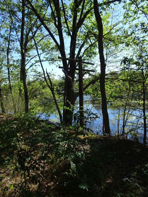
Water views along the SNETT in Blackstone
Last summer the Massachusetts Walking Tour used the SNETT trail to travel between Bellingham, Franklin and Blackstone, avoiding a lot of road walking by using this still being developed trail system. I was able to confidently assure the group about much of the trail, but the section in Blackstone near Farm Street was not an area I had visited.
It was one of those weekends with a lot of plans, but I needed to get a walk in before sitting the rest of the day in a meeting.

Cranberry plants alongside the trail. Alas, no berries…
A local walk was called for, and we ended up on Farm Street in Blackstone, at the northern edge of Harris Pond, along the SNETT.

Touch of fall color along the trail
I enjoy walking in the woods, but when a walk includes water views, it really makes my day. Turns out that a goodly portion of this section of trail offers water views on both sides of the trail. The fall colors are just starting to show; peak foliage season is still a few weeks away in early October.

Remnants of some type of ng the trail
We spotted wetlands protection non-woven fabric alongside the trail–clearly in the past several years others had been through here. Was this when the sewer manholes that are spaced along the trail were installed? Did DCR come through and blade the humps and bumps down?

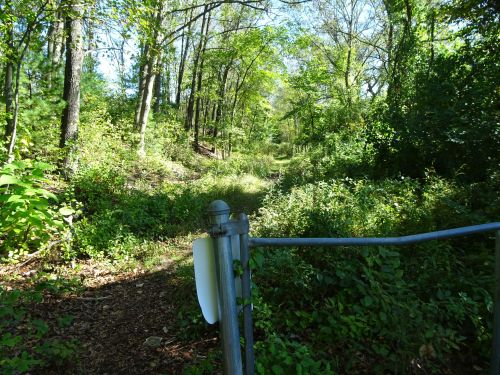
Rather unwelcoming sign at Farm Street Entrance to the SNETT
Hard to say, but what is clear is that, despite the warning signs at the gate facing onto Farm Street, this section of the SNETT that travels west and intersects with Castle hill condos in Blackstone is very walkable, and provides some lovely water views along the way.

Vehicles could travel on this trail easily for much of this section of the SNETT
We spotted one mountain biker following the trail as we walked, but otherwise this appears to be an infrequently used portion of the SNETT. It would benefit from some additional brushing out but the footing was good, and we enjoyed the short trek.
The sign says, “no dogs” when passing the gate and encountering the roads of Castle Hill condos.
Once we reached the gate on the western section we encountered pavement and a condo complex, CAstle Hill condos. The SNETT continues westward, but this section of trail is neither marked nor obvious. Passing by the gate of the designated trail there is also a “No dogs” sign, something to keep in mind if one uses these trails to get out with your four-legged friends.
Progress is slow, but I remain hopeful that as people flock to the finished section of trail in Blackstone that traverses eight bridges on its way to Uxbridge, they push will get stronger to finish and connect the additional trail links on this railtrail, still a work in progress.
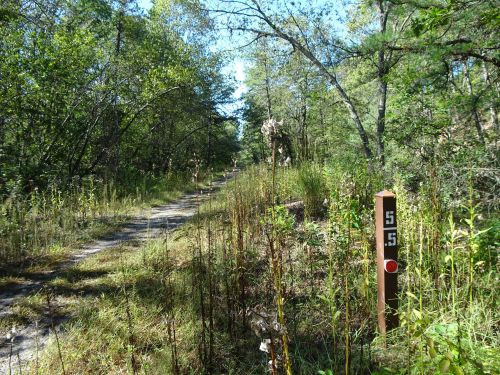
SNETT mile marker along the trail. Progress!
Marjorie
Marjorie Turner Hollman is a writer who loves the outdoors, and is the author of Easy Walks in Massachusetts, 2nd edition, More Easy Walks in Massachusetts, 2nd edition, Easy Walks and Paddles in the Ten Mile River Watershed, and Finding Easy Walks Wherever You Are. Her memoir, the backstory of Easy Walks, is My Liturgy of Easy Walks: Reclaiming hope in a world turned upside down.

Can you explain the demarcations of the mile markers? Does that one in the picture mean one has reached mile 5.5? The underscoring of the top number confuses me. Thanks!
HI, looks like Jim Spear answers your question–Thanks, Jim!
The mile markers start their measure from the trail-head in Franklin on grove street and work west toward Main st. In Blackstone (ft. 122) . So , if you walked from grove st. , to mm. 5.5 , you have indeed walked that distance . The mms. Are half a mile apart . Top number full number ,bottom number is either .o or 5 .
Thank you! So far I’ve only walked small sections, so it was a bit confusing to me. I’ve seen them between Center St and Lake St. It will help me gauge my distances now. 🙂
Thanks so much, Jim!
I’ve actually walked the SNETT from Rt. 495 in Franklin to Rt. 395 in East Thompson , Conn. in legs . I could never do it in one trip . With the curves of the rail beds , it’s about 30 miles , basicly the entire northern RI. boarder , and then some .
Wow! I’m jealous!
I”ve seen folks on bicycles (which makes this a little more manageable) but there are still portions (such as when one ends up where we did, at Castle hIll condos and getting back onto the SNETT in Blackstone at Canal street, as well as at Rt 146A in Uxbridge) where street walking is required, and where the route is not clearly marked. But all the public interest, and having people out on the trails is all pressure to get the trail better marked and more connected. What you’re doing simply by spending time out there is important!