

Out with our tandem in the summer, cooling vest on, cooling scarf as well, ready to have fun regardless of the heat
We love to get our tandem bike out on local, and not so local railtrails, but as we search the internet for information about trail conditions of various trails we discover, we find some consistent challenges. Websites are not updated. Parking areas often lack signage pointing to where they are located. And perhaps the most important issue–it is nearly impossible to ascertain trail conditions from the available information out there.
GoogleEarth is a great help in giving us clues. Websites sometimes refer to trail conditions. But we often find big discrepancies between what is reported and what we find when we head out to the trail.

Parking area found on Glenwood Road in Rutland. Getting ready to head out.
We headed to Rutland, MA recently to take a ride, and see for ourselves what this section of the Mass Central Railtrail looked like. From our investigations using GoogleEarth, we believed we’d get some nice water views along the trail, as long as the trail itself was passable.
It took some doing to discover the parking area on Glenwood Road in Rutland, off Wachusett Street, but we finally found parking for about five cars. The trail heading back east, toward the other section of this trail system in Boyleston is still a narrow footpath. But heading west toward the town of Ware the path is crushed stone, standard width, an improved railtrail that was a true joy to travel on.

Mountain laurel blossoms (late June) alongside the trail
On the eastern portion of our ride we enjoyed views of large clumps of mountain laurel, at the end of their season. The rest of the trail was noticeably devoid of of the woodland flowers.

WAter views alongside the trail
Farther along we got our hoped for water views, on both sides of the elevated trail.

More water views
We saw few people on the the trail–this appears to be an underused spot. Fine by us.

Taking a break in the shade on this quiet trail
One section of the trail came out onto a country road, with no signs to indicate where the trail resumed. But we were able to find, at Miles Road, just off Rt. 56, less that 100 yards around the bend, another parking area and the opening to get back off road onto the railtrail. After following the trail for ten miles, we came to the end of this completed section, next to Rt. 122, at a parking area in Ware, alongside the Ware River, quite near Powder Mill Pond.

Some lovely river views alongside the trail
At the parking area we found an information kiosk describing this area as the entrance to the “Hidden Valley,” a section of the state where towns were obliterated to create the Quabbin reservoir between 1930 and 1939. We did not have time to investigate this further–something for another trip!
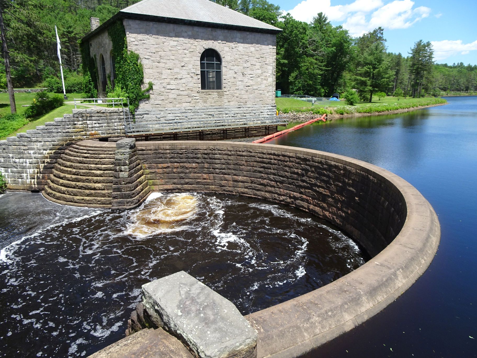
Pump station along the river
Just prior to the end of the trail in Ware, we came across a pump station. The stonework for the building was impressive. We’d brought along lunch, and found a shady spot alongside the river to take a break before heading back along the trail.

Memorial to a train wreck
Since this is a railtrail, its history naturally includes railroads–historical markers recalled a fatal train accident, while another marker provided information about a spot where trains got water along the way.

Storm clouds headed our way as we peddled back
Clouds started coming in as we pedaled back, and we stopped for just a few pictures as the wind picked up. Our bike was safely stowed just minutes before the rain hit. We were grateful we’d gotten a relatively early start. Some bikers were headed out just as we left–much hardier souls than we are. But this is a place that is worth the trip.
Marjorie
Marjorie Turner Hollman is a writer who loves the outdoors, and is the author of Easy Walks in Massachusetts, 2nd edition, More Easy Walks in Massachusetts, 2nd edition, Easy Walks and Paddles in the Ten Mile River Watershed, and Finding Easy Walks Wherever You Are. Her memoir, the backstory of Easy Walks, is My Liturgy of Easy Walks: Reclaiming hope in a world turned upside down.

I concur with your statement that more information is needed with many of these trails. Thank goodness you are helping with this!
Thanks for your encouragement, Mary–glad to have you along for the ride!